|

Home
Intersecting Highways:
Interstate 35
Interstate 44
Interstate 244
U.S. 54
U.S. 56
U.S. 59
U.S. 60
U.S. 64
U.S. 69
U.S. 75
U.S. 77
U.S. 81
U.S. 83
U.S. 169
U.S. 177
U.S. 183
U.S. 270
U.S. 281
U.S. 283
U.S. 287
U.S. 385
OK 3
OK 8
OK 10
OK 11
OK 15 (E)
OK 15 (W)
OK 18
OK 23
OK 34
OK 46
OK 48
OK 50
OK 51
OK 58 (N)
OK 66
OK 74 (N)
OK 82 (N)
OK 88
OK 94
OK 95
OK 97
OK 97T
OK 99
OK 132
OK 136
OK 151
OK 167
OK 171
OK 325
OK 412B
OK 412P
Latest Updates
Interstate Highways
U.S. Highways
State Highway
Terminus Gallery
E-mail
OKHighways.com
(Spam filter in effect: Use @ in place of #) |
|
Highway
Review:
U.S. 412 runs from Springer, New Mexico to Columbia, Tennessee.
It is designated U.S. 412 not because of its proximity to U.S. 12
(actually, U.S. 12 is several hundred miles to the north in North
Dakota!), but because it is a high-priority corridor.
U.S. 412 is 4-laned
from Enid all the way to Springdale, Arkansas. It replaced OK 33
east of Tulsa. The Cimarron Turnpike between Interstate 35 and
the Keystone Lake area and the Cherokee Turnpike between Chouteau
and West Siloam Springs are parts of U.S. 412 as well.
Since the highway's
commissioning is relatively recent (late 1980's/early 1990's),
the highway has several long duplexes throughout its travels
through New Mexico, Oklahoma, Arkansas, Missouri, and Tennessee.
Oklahoma's stretch of U.S. 412 is no exception. After leaving New
Mexico and entering Oklahoma, U.S. 56, U.S. 62, and U.S. 412 go
28 miles without a sight of a highway. The three highways head
through Boise City and are joined by U.S. 287, U.S. 385, and OK
3, creating a 5-highway duplex in some places! Just east of Boise
City, U.S. 287 leaves, but U.S. 56, U.S. 64, U.S. 412, and OK 3
are duplexed for six more miles, before U.S. 56 leaves. This
means that there are still three highways signed on one road!
Between Guymon and U.S. 270, the highway is only duplexed by OK
3. U.S. 412 is duplexed with another highway from its western
terminus in Springer, NM (duplexed with U.S. 56) all the way to
Woodward. U.S. 412 replaced OK 15 between Woodward and Garber.
U.S. 412 is joined by U.S. 60 30 miles west of Enid and are
duplexed until U.S. 60 departs. U.S. 412 is alone for just three
miles, as U.S. 64 joins U.S. 412 on the east side of Enid. U.S.
64 and U.S. 412 is a 4-lane divided expressway between Enid and
Interstate 35, with an interchange at OK 15 East/OK 74. After
U.S. 64 leaves U.S. 412 at Interstate 35, U.S. 412 becomes the
Cimarron Turnpike. The turnpike ends up near Lake Keystone west
of Tulsa. U.S. 64 rejoins U.S. 412 at the turnpike's eastern
terminus and remain duplexed until U.S. 64 finally leaves U.S.
412 for good at Interstate 244. U.S. 412 then joins Interstate
244 East and are duplexed until the interstate's eastern
terminus, where U.S. 412 then joins Interstate 44 and OK 66 for a
few miles. After Interstate 44 and OK 66 depart within a mile of
each other, U.S. 412 is not duplexed with another highway for
almost its entire distance remaining in Oklahoma. East of
Chouteau and the U.S. 69 cloverleaf interchange, U.S. 412 becomes
the Cherokee Turnpike, which runs from Chouteau to about eight
miles west of the Arkansas State Line. U.S. 59 joins the highway
at the turnpike's eastern terminus and leaves just one-tenth of a
mile before U.S. 412 crosses the state line into Arkansas.
Highway
Information:
Distance: 502.6 miles
Counties traveled through: Cimarron, Texas, Beaver, Harper,
Woodward, Major, Garfield, Noble, Payne, Pawnee, Tulsa, Rogers,
Mayes, Delaware
Highway intersections: U.S. 385 (Mile 28.4), U.S. 287/385/OK 3/OK 325
(Mile 31.8), U.S. 287 (Mile 33.5), U.S. 56 (Mile 39.5), OK 171
(Mile 47.2), OK 95 (Mile 66.0), OK 95 (Mile 71.0), OK 136 (Mile
89.4), U.S. 64 (Mile 93.5), U.S. 54 (Mile 94.3), U.S. 54/OK 136
(Mile 94.7), OK 94 (Mile 109.2), U.S. 83 (Mile 132.4), U.S.
270/OK 23 (Mile 149.4), U.S. 283 (Mile 184.5), OK 46 (Mile
192.6), OK 46 (Mile 192.7), U.S. 183 (Mile 202.2), OK 15 (Mile
216.0), U.S. 183/270/OK 3/34 (Mile 218.1), OK 50 (Mile 226.3), OK
50 (Mile 228.6), U.S. 281 (Mile 246.4), U.S. 60/OK 8 (Mile
270.8), OK 8 (Mile 273.7), OK 58 (Mile 284.6), OK 132 (Mile
296.5), OK 132 (Mile 297.5), U.S. 60/81 (Mile 304.5), Bus. U.S.
64 (Mile 305.1), U.S. 64 (Mile 307.5), OK 15/74 (Mile 321.5),
Interstate 35/U.S. 64 (Mile 335.7), U.S. 77 (Mile 338.2), U.S.
177 (Mile 350.7), U.S. 64 (Mile 358.6), OK 18 (Mile 372.5), OK 99
(Mile 384.5), OK 48 (Mile 394.4), U.S. 64 (Mile 394.8), OK 151
(Mile 404.6), OK 51/OK 97 (Mile 412.5),
Interstate 244/U.S. 64/OK 51 (Mile 419.2), U.S. 75 (Mile 420.6),
OK 11 (Mile 426.1), U.S. 169 (Mile 427.4), Interstate 44/244/OK
66 (Mile 429.3), OK 167 (Mile 433.1), OK 66 (Mile 433.7),
Interstate 44 (Mile 435.1), OK 412P (Mile 440.2), OK 88 (Mile
446.9), U.S. 69 (Mile 456.7), Scenic U.S. 412 (Mile 461.5), OK 82
(Mile 467.4), Scenic U.S. 412 (Mile 478.2), U.S. 59/OK 10 (Mile
489.3), U.S. 59/Scenic U.S. 412 (Mile 494.0), U.S. 59 (Mile
502.5)
Highway duplexes: U.S. 56 (Miles 0.0-39.5, 39.5 miles), U.S. 64
(Miles 0.0-93.5, 93.5 miles), U.S. 385 (Miles 28.4-31.8, 3.4
miles), U.S. 287 (Miles 31.8-33.5, 1.7 miles), OK 3 (Miles
31.8-218.1, 186.3 miles), OK 95 (Miles 66.0-71.0, 5.0 miles), OK
136 (Miles 89.4-94.7, 5.3 miles), U.S. 54 (Miles 94.3-94.7, 0.4
miles), U.S. 270 (Miles 149.4-218.1, 68.7 miles), U.S. 183 (Miles
202.2-218.1, 15.9 miles), OK 50 (Miles 226.3-228.6, 2.3 miles),
U.S. 60 (Miles 270.8-304.5, 33.7 miles), OK 8 (Miles 270.8-273.7,
2.9 miles), OK 132 (Miles 296.5-297.5, 1.0 mile), U.S. 64 (Miles
307.5-335.7, 28.2 miles), U.S. 64 (Miles 394.8-419.2, 24.4
miles), OK 51 (Miles 412.5-419.2, 6.7 miles), Interstate 244
(Miles 419.2-429.3, 10.1 miles), OK 66 (Miles 429.3-433.7, 4.4
miles), Interstate 44 (Miles 429.3-435.1, 5.8 miles), U.S. 59
(Miles 494.0-502.5, 8.5 miles)
PICTURES
 |
"Oklahoma" sign as U.S. 56, U.S. 64, and U.S. 412
East enter
the Sooner State. (Photo taken 5/7/04) |
 |
U.S. 56/U.S. 64/U.S. 412 East at
U.S. 385 South near
Boise City. (Photo taken 5/7/04) |
 |
U.S. 56/U.S. 64/U.S. 412 East/U.S.
385 North at the Boise
Boise City traffic circle. The Cimarron County Courthouse
sits in the middle of this circle, which helps facilitate movements
between six highways. (Photo taken 5/7/04) |
 |
U.S. 56/U.S. 64/U.S. 412/OK 3 West/U.S.
287 North at the
Boise City traffic circle. (Photo taken 5/7/04) |
 |
Inside the traffic circle, this would be U.S. 56/U.S. 64/U.S. 412/
OK 3 East/U.S. 287 South/U.S. 385
North at U.S. 56/U.S. 64/
U.S. 412/OK 3 East/U.S. 287 South. U.S. 64 and OK 3 are not
signed here, but that is all right. There are too many highways
here to fit them all into one sign! (Photo taken 5/7/04) |
 |
Inside the traffic circle, this would be U.S. 56/U.S. 64/U.S. 412/
OK 3 West/U.S. 287/U.S. 385 North at
U.S. 287/U.S. 385 North/
OK 3 West. U.S. 287 does eventually connect to Denver, and a
sign just north of town gives the mileage to Colorado's capital
city. (Photo taken 5/7/04) |
 |
Inside the traffic circle, this would be U.S. 56/U.S. 64/U.S. 412
West/U.S. 287/U.S. 385 South/OK 3
East at OK 325 West -
Kenton. OK 325 is 38 miles long and these highways here are
the
only ones it connects to. It is also the highway that one takes
to
get to Black Mesa, Oklahoma's highest point. (Photo taken
5/7/04) |
 |
Inside the traffic circle, this would be U.S. 56/U.S. 64/U.S. 412
West/U.S. 287/U.S. 385 South/OK 3
East at U.S. 56/U.S. 64/
U.S. 412 West/U.S. 385 South. U.S. 385 is left off of this sign.
(Photo taken 5/7/04) |
 |
U.S. 56/U.S. 64/U.S. 412/OK 3 West/U.S.
287 North assurance
shields just east of Boise City. This area is known for its
highway multiplexes. (Photo taken 5/7/04) |
 |
U.S. 56/U.S. 64/U.S. 412/OK 3 East/U.S.
287 South at U.S.
287 South. (Photo taken 5/7/04) |
 |
U.S. 56/U.S. 64/U.S. 412/OK 3 East
at U.S. 56 East. (Photo
taken 5/7/04) |
 |
U.S. 64/U.S. 412/OK 3 West at OK
171. There are no signs at
the actual intersection for OK 171. I counted more deer on OK
171 than other vehicles on this day! (Photo taken 5/7/04) |
 |
U.S. 64/U.S. 412/OK 3 West/OK 95
North at OK 95 North.
(Photo taken 5/7/04) |
 |
U.S. 64/U.S. 412/OK 3 West/OK 95
North assurance shields
in western Texas County. OK 95 runs along this road for five
miles. (Photo taken 5/7/04) |
 |
U.S. 64/U.S. 412/OK 3 East/OK 136
South assurance shields
just north of Guymon. (Photo taken 5/7/04) |
 |
U.S. 64/U.S. 412/OK 3 East/OK 136
South at U.S. 64 East in
Guymon. This is also the truck route for U.S. 64, U.S. 412, OK
3, and OK 136 traffic to bypass downtown Guymon, which is
less than a mile ahead. (Photo taken 5/7/04) |
 |
U.S. 412/OK 3 East/OK 136 South at
U.S. 54 in Guymon.
(Photo taken 5/7/04) |
 |
U.S. 54/U.S. 412/OK 3 West/OK 136
North at Business U.S.
412/OK 3 West/OK 136 North in Guymon. The "Business"
tab is there because truck traffic on U.S. 412/OK 3/OK 136
uses a slightly different route to the north to bypass downtown
Guymon. (Photo taken 5/7/04) |
 |
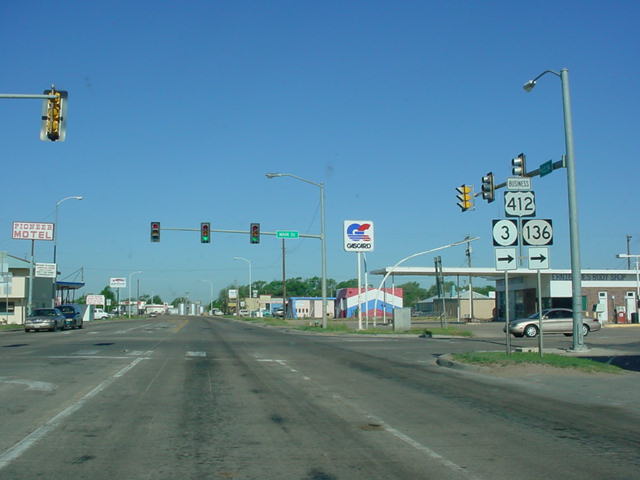
U.S. 54/U.S. 412/OK 3 East/OK 136
South at U.S. 412/OK
3 East/OK 136 South in Guymon. (Photo taken 5/7/04) |
 |
U.S. 412/OK 3 West/OK 136 North at
U.S. 54 in Guymon.
U.S. 54 is the cross street. (Photo taken 5/7/04) |
 |
U.S. 412/OK 3 East/OK 136 South at
OK 136 South in
Guymon. (Photo taken 5/7/04) |
 |
U.S. 412/OK 3 West at OK 136 South
in Guymon. U.S. 54 is
at the stoplight just ahead. (Photo taken 5/7/04) |
 |
U.S. 412/OK 3 East at OK 94 North
near Hardesty. OK 94
connects to U.S. 54/U.S. 64 in Hooker at its other end.
(Photo taken 5/7/04) |
 |
U.S. 412/OK 3 East at U.S. 83.
(Photo taken 5/7/04) |
 |
U.S. 412/OK 3 West at U.S. 83.
(Sorry about the sun glare.)
(Photo taken 5/6/04) |
 |
U.S. 412/OK 3 East at U.S. 270 West
and OK 23. (Photo
taken 5/7/04) |
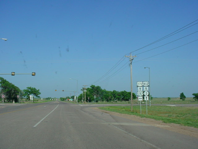
 |
U.S. 270/U.S. 412/OK 3
East at U.S.
283. (Photo taken 5/7/04) |
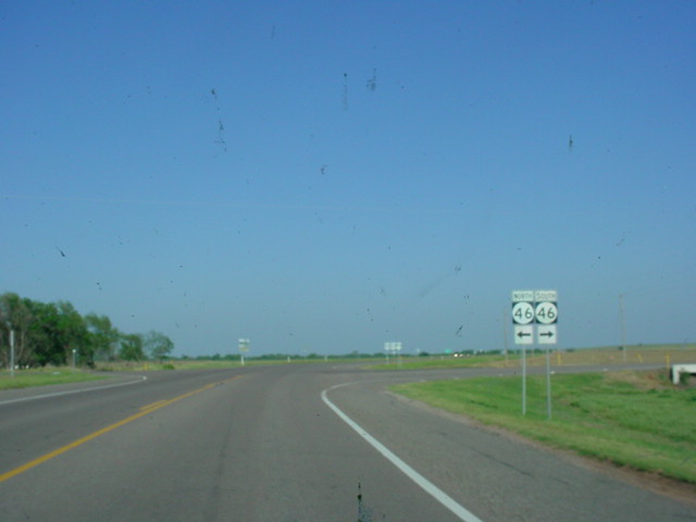
 |
U.S. 270/U.S. 412/OK 3
East at OK
46. (Photo taken 5/7/04) |
 |
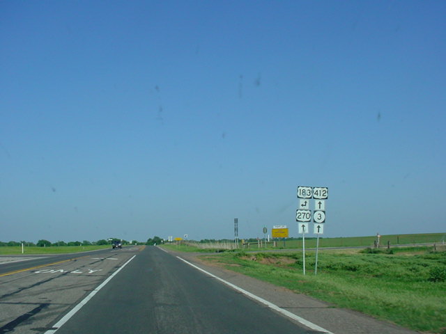
U.S. 270/U.S. 412/OK 3
East at U.S.
183 North near Fort
Supply. (Photo
taken 5/7/04) |
 |
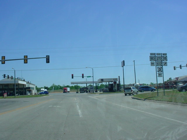
U.S. 183 South/U.S. 270/U.S. 412/OK 3 East
at OK 15 West
in Woodward. U.S. 412 replaced OK 15 between this
intersection and Garber, where the eastern OK 15 now begins.
(Photo taken 5/6/04) |
 |
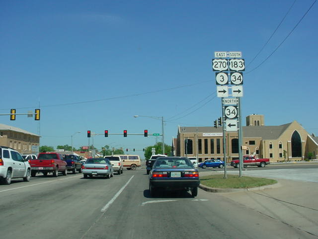
U.S. 183 South/U.S. 270/U.S. 412/OK 3 East
at OK 34 in
Woodward. U.S. 412 continues straight ahead while U.S. 183,
U.S. 270, and OK 3 all head south with OK 34. (Photo taken
5/6/04) |
 |
U.S. 412 East at OK 50 South near
Mooreland. The two
highways have a 2-mile duplex. (Photo taken 5/6/04) |
 |
U.S. 412 East/OK 50 North at OK 50
North in Mooreland.
(Photo taken 5/6/04) |
 |
OK
(should be U.S.) 60/U.S 412 East/OK
8 North assurance
shields located just west of Cleo Springs. (Photo taken 4/9/04) |
 |
U.S. 60/U.S. 412 East/OK 8 North at
OK 8 North. (Photo
taken 4/9/04) |
 |
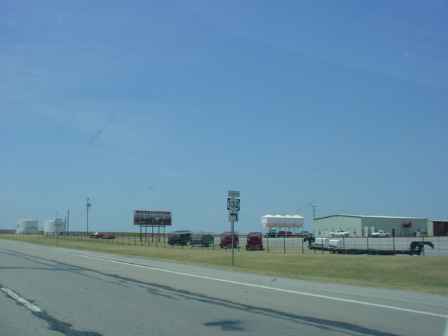
U.S.
60/U.S. 412 West/OK 132 South at OK 132 South. (Photo
taken 7/18/03) |
 |
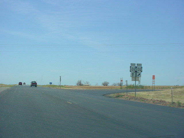
U.S. 60/U.S. 412
West at OK 132 North. OK 132 joins the two
federal highways for the next mile. (Photo taken
7/18/03) |
 |
U.S.
64/U.S. 412 West at OK 15
East/OK 74 - Garber/
Covington exit. The interchange is located halfway
between
Enid and Interstate 35. (Photo taken 7/18/03) |
 |
U.S. 64/U.S. 412 East approaching
Interstate 35/Cimarron
Turnpike - 1 mile. (Photo taken 5/21/04) |
 |
U.S. 64/U.S. 412 East approaching
Interstate 35 - 3/4 mile.
(Photo taken 5/21/04) |
 |
U.S. 64/U.S. 412 East approaching
Interstate 35 South/U.S.
64 East - 1/2 mile. (Photo taken 5/21/04) |
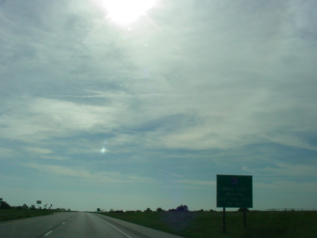
 |
U.S. 64/U.S. 412 East at Interstate
35 South/U.S. 64 East -
Perry/Oklahoma City. U.S. 412 becomes the Cimarron Turnpike
ahead. (Photo taken 5/21/04) |
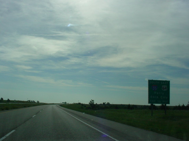
 |
U.S. 412 East at Interstate 35 North
- Wichita. This is the
last free exit before the toll road begins. (Photo taken
5/21/04) |
|
CIMARRON
TURNPIKE |
 |
U.S. 64/U.S. 412 West approaching
U.S. 64 West TO OK 48 -
1 mile. The interchange marks the western end of the Keystone
Expressway and the beginning of the Cimarron Turnpike. (Photo
taken 5/21/04) |
 |
U.S. 64/U.S. 412 West approaching
U.S. 412/Cimarron
Turnpike West - 1 mile. (Photo taken 5/21/04) |
 |
U.S. 64/U.S. 412 West approaching
U.S. 64 West - 1/2 mile.
(Photo taken 5/21/04) |
 |
U.S. 64/U.S. 412 West at U.S. 64
West TO OK 48 - Cleveland/
Pawnee/Bristow. (I apologize for the sun glare.) (Photo taken
5/21/04) |

 |
U.S. 64/U.S. 412
East at Westport Rd. exit along the Keystone
Expressway. This is one of few exits along the expressway that
have a sign at the actual exit. (Top photo taken 1/7/03, bottom
photo taken 5/21/04) |
 |
U.S. 64/U.S. 412 West at Westport
Rd. (Photo taken 5/21/04) |

 |
U.S. 64/U.S. 412
East at Bears Glen exit. The
interchange
accesses some local lake-related housing and activities. (Top
photo taken 1/7/03, bottom photo taken 5/21/04) |
 |
U.S. 64/U.S. 412 West at Bears Glen.
(Photo taken 5/21/04) |
 |
U.S. 64/U.S. 412 East approaching OK
151 South - 3/4 mile.
OK 151 connects U.S. 64 and U.S. 412 to OK 51 and goes
over the Lake Keystone dam. (Photo taken 5/21/04) |
 |
U.S. 64/U.S. 412 West approaching OK
151 South - Keystone
Dam/TO SH-51 - 3/4 mile. (Photo taken 5/21/04) |
 |
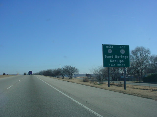
U.S. 64/412
East at 209th W. Ave. exit west of Sand Springs.
Several exits have just a "Next Right" sign approaching the exit,
which is mostly an uncommon sight in Oklahoma. (Photo
taken 1/7/03) |
 |
U.S. 64/U.S. 412 West at 209th W.
Ave. (Photo taken 5/21/04) |
|
|
U.S. 64/412
East at
Westport Rd. exit. This exit is one of several
which lead to the Keystone Lake area. (Photo taken
1/7/03) |
|
|
U.S. 64/U.S. 412
East at
Bears Glen exit. (Photo taken 1/7/03) |
|
|
U.S. 64/U.S. 412
East at
209th W. Ave. exit. (Photo taken
1/7/03) |
 |
U.S. 64/U.S. 412
East at
177th W. Ave. exit. (Photo taken
1/7/03) |
 |
U.S. 64/U.S. 412
East
approaching OK 51 West/OK 97 - 1
mile.
Notice the old button copy shields. (Photo taken
1/7/03) |
 |
U.S. 64/U.S. 412
East at
OK 51 West/OK 97 exit. (Photo taken
1/7/03) |
 |
U.S. 64/U.S. 412
West at Gilcrease Museum Road exit. (Photo
taken 12/1/02) |
 |
U.S. 64/U.S. 412
East at
Quanah Ave. exit in Tulsa. Interstate
244
is 1/4 mile away, and the downtown Tulsa skyline is
drawing
closer. (Photo taken 12/1/02) |
 |
U.S. 64/U.S. 412
East
approaching Interstate 244 exits. U.S.
412
is the only highway that continues straight ahead. (Photo
taken
12/1/02) |
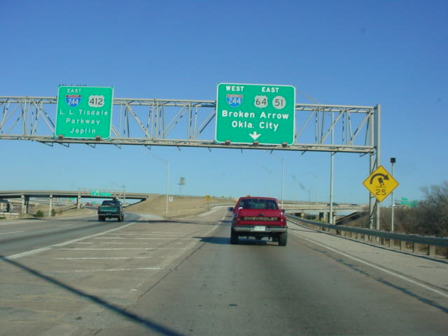
 |
U.S. 64/U.S. 412
East at
Interstate 244 West/U.S. 64/OK 51
East
exit. U.S. 412 joins Interstate 244 East on the other
side
of the
overpass ahead. (Photo taken 12/1/02) |
INTERSTATE 244 DUPLEX
(Exits 5B-16) |
 |
Interstate 44/U.S.
412 West at Interstate 244/U.S. 412 exit.
(unmarked Exit 236B) (Photo taken 2/14/03) |
 |
Although no signs
indicate that this is it, this is Interstate 44/U.S.
412/OK 66 East at Exit 240 - OK 167 North. (Photo
taken
11/28/02) |
 |
Interstate 44/U.S.
412/OK 66 East at Exit 241 - OK 66 East -
Catoosa/Claremore. Interstate 44 used to exit off here as
well
before it was extended down U.S. 412 a mile to the Creek
Turnpike. (Photo taken 11/28/02) |
 |
Interstate 44/U.S.
412 East at U.S. 412 East exit. The Creek
Turnpike West exit is 1/2 mile ahead. (Photo taken
11/28/02) |
 |
U.S. 412 West at
Interstate 44 East exit. (Photo taken 2/14/03) |
 |
U.S. 412 West at
Creek Turnpike West exit. The turnpike loops
around Tulsa and connects to the Turner Turnpike near
Sapulpa.
(Photo taken 2/14/03) |
 |
U.S. 412 West
approaching Interstate 44 East exit - 1/2 mile.
(Photo taken 2/14/03) |
 |
U.S. 412 West at OK 412P East. OK 412P, not marked on
any maps, does exist! (Photo taken 2/14/03) |
 |
U.S. 412 West at OK 88 - Inola/Claremore exit. (Photo taken
2/14/03) |
 |
U.S. 412 West at U.S. 69 South - Wagoner exit. (Photo taken
2/14/03) |
 |
U.S. 412 West at
U.S. 69 North - Chouteau exit. (Photo taken
2/14/03) |
 |
U.S. 412 West at OK 412B North. OK
412B connects U.S.
412 to the Mid-America Industrial Park near Chouteau.
(Photo taken 5/21/04) |
|
CHEROKEE TURNPIKE |
 |
U.S. 59 South/U.S. 412 East at U.S.
59 South. U.S. 412
enters Arkansas just past this stoplight. (Photo taken 9/4/03) |
|