|

Home
Intersecting Highways:
Interstate 40
Interstate 44
U.S. 60
U.S. 62
U.S. 64
U.S. 70
U.S. 270
U.S. 277
U.S. 412
OK 3
OK 5 (E)
OK 5A
OK 7
OK 8
OK 9
OK 11
OK 14
OK 15 (W)
OK 19
OK 33
OK 36
OK 37 (N)
OK 45
OK 49
OK 51
OK 58 (N)
OK 152
Latest Updates
Interstate Highways
U.S. Highways
State Highway
Terminus Gallery
E-mail
OKHighways.com
(Spam filter in effect: Use @ in place of #) |
|
Highway
Review:
U.S. 281 might be a "child route" of U.S. 81, but it
runs longer than its parent route! U.S. 81 runs from Fort Worth,
Texas to the Canadian border, while U.S. 281 connects the Mexico
border to the Canadian border in North Dakota.
As it heads into the
Sooner State, U.S. 281 is signed with Interstate 44 and U.S. 277.
At Exit 5 for U.S. 70, U.S. 277/281 exit off I-44 and head east
with U.S. 70 for three miles. Then the two highways head north
until they intersect OK 5, then they head east for a few miles.
Just east of Interstate 44, the highways head north once again
and join Interstate 44 at its Exit 30. Sixteen miles later, after
traveling through Lawton, U.S. 281 heads north, still signed with
U.S. 277 and since Exit 40, signed with U.S. 62. Four miles north
of the exit off the interstate U.S. 277 heads east, and U.S. 62
and 281 remain co-signed until almost 40 miles north of the U.S.
277 splitoff in Anadarko, where U.S. 281 then takes on OK 8 for
over 60 miles!
U.S. 281 and OK 8
head through Binger, Lookeba, and Hinton before intersecting
Interstate 40 at Exit 101. In the town of Geary, U.S. 270 joins
U.S. 281/OK 8 and are joined for 54 miles before splitting apart
in Seiling. The highway continues to be co-signed with another
U.S. or state highway all the way to Chester, which is north of
Seiling. The highway is finally just U.S. 281 for over 50 miles
until Alva (pop. 5,288), the home of Northwestern Oklahoma State
University, when U.S. 281 joins U.S. 60 for almost a mile. Alva
is also the final major Oklahoma town along its route, and before
long motorists traveling U.S. 281 can cross another state off the
list of six states the route serves as it connects the United
States' two bordering countries. Out of its over 250 miles in
Oklahoma, only 67.2 (26%) of its miles are not co-signed with
another highway!
Highway
Information:
Distance: 256.6 miles
Counties traveled through: Cotton, Comanche, Caddo, Canadian,
Blaine, Dewey, Major, Woods
Highway intersections: Interstate 44 (Mile 5.1), U.S. 70 (Mile
5.1), U.S. 70 (Mile 8.0), OK 5A (Mile 15.1), OK 5 (Mile 21.1),
Interstate 44 (Mile 23.5), OK 5 (Mile 23.9), Interstate 44/OK 36 (Mile
34.4), Business U.S. 281 (Mile 37.9), OK 7 (Mile 41.2), Business
U.S. 281 (Mile 43.6), U.S. 62 (Mile 44.7), OK 49 (Mile 49.9),
Interstate 44 (Mile 50.9), U.S. 277 (Mile 55.2), OK 19 (Mile
64.1), OK 19 (Mile 64.7), OK 9 (Mile 74.9), U.S. 62/OK 8/9 (Mile
83.2), OK 152 (Mile 98.8), OK 152 (Mile 103.5), OK 37 (Mile
115.7), Interstate 40 (Mile 119.8), Spur U.S. 281 (Mile 122.9),
U.S. 270 (Mile 128.6), OK 3/8/33 (Mile 145.6), OK 33/58 (Mile
155.2), OK 51 (Mile 175.0), U.S. 60/OK 51 (Mile 183.5), U.S.
270/OK 3 (Mile 184.0), U.S. 60 (Mile 188.5), U.S. 412/OK 15 (Mile
203.5), OK 14/OK 45 (Mile 215.2), OK 45 (Mile 227.3), U.S. 64 (Mile
241.6), U.S. 64 (Mile 242.5), OK 11 (Mile 249.6)
Highway duplexes: Interstate 44 (Miles 0.0-5.1, 5.1 miles), U.S.
277 (Miles 0.0-55.2, 55.2 miles), U.S. 70 (Miles 5.1-8.0, 2.9
miles), OK 5 (Miles 21.1-23.9, 2.8 miles), Interstate 44 (Miles
34.4-50.9, 16.5 miles), U.S. 62 (Miles 44.7-83.2, 38.5 miles), OK
19 (Miles 64.1-64.7, 0.6 miles), OK 9 (Miles 74.9-83.2, 8.3
miles), OK 8 (Miles 83.2-145.6, 62.4 miles), OK 152 (Miles
98.8-103.5, 4.7 miles), U.S. 270 (Miles 128.6-184.0, 55.4 miles),
OK 3 (Miles 145.6-184.0, 38.4 miles), OK 33 (Miles 145.6-155.2,
9.6 miles), OK 51 (Miles 175.0-183.5, 8.5 miles), U.S. 60 (Miles
183.5-188.5, 5.0 miles), OK 45 (Miles 215.2-227.3, 12.1 miles), U.S. 64 (Miles 241.6-242.5, 0.9 miles)
PICTURES
 |
U.S. 277/U.S. 281 South at U.S. 70
in
Randlett. U.S. 277 and U.S. 281 head west
on U.S. 70 for three miles to Interstate 44.
(Photo taken 5/12/04) |
 |
U.S. 277/U.S. 281 South at OK 5A
East in
Cookietown. OK 5A connects to OK 5 south
of Walters at its other end. (Photo taken
5/12/04) |
 |
U.S. 277/U.S. 281
North as it
approaches
Interstate
44 south of Lawton. OK 36's northern
terminus is just ahead, thus the mention of that
highway
junction is present as well. (Photo taken
9/6/02) |
 |
Interstate 44/U.S. 62 East and
U.S. 277/U.S.
281 North at Exit 46 - U.S. 62 East/U.S. 277/
U.S. 281
North. The H.E. Bailey Turnpike starts
up once
again following this interchange. (Photo
taken
9/6/02) |
 |
U.S. 62/OK 9 East/U.S. 281
North
at Mission
Ave. stoplight in Anadarko. The three highways
head north at this point for about a mile before
they head east once again. (Photo taken
11/26/02) |
 |
In Anadarko, the point where U.S.
62/U.S. 281/
OK 9
head toward the east once again. (Photo
taken
11/26/02) |
 |
U.S. 62/OK 9 East/U.S. 281
North
at U.S. 281/
OK 8 North near downtown Anadarko. U.S. 281
and OK 8 begin their 62-mile joint venture at this
light. (Photo taken 11/26/02) |
 |
U.S. 281/OK 8
North at OK 152 east
of Binger.
These three highways are joined for 4.7 miles
before U.S. 281 and OK 8 head north towards
Hinton. (Photo taken 11/26/02) |
 |
U.S. 281/OK 8
North/OK 152 West
shields just
west of the intersection pictured above. (Photo
taken 11/26/02) |
 |
U.S. 281/OK 8
North/OK 152 West at
U.S. 281/
OK 8 North in Binger. Binger is mostly known for
being the birthplace of Baseball Hall of Fame
catcher
Johnny Bench. (Photo taken 11/26/02) |
 |
U.S. 281/OK 8
North assurance shields just
north of
Binger. (Photo taken 11/26/02) |
 |
U.S. 281/OK 8
North at OK 37 East
in Hinton.
This is OK 37's western terminus. Also notice
the wall mural on the building to the right. (Photo
taken 11/26/02) |
 |
U.S. 270 East/U.S. 281/OK 8 South at
U.S.
270 East in Geary. (Photo taken 5/7/04) |
 |
U.S. 270/OK 3/OK 33 East/U.S. 281 South
at
U.S. 270 East/U.S. 281 South/OK 8 in
Watonga. (Photo taken 4/9/04) |
 |
U.S. 270/U.S. 281/OK 3/OK 33 East assurance
shields just east of OK 33 West/OK 58 North.
This sign assembly should have U.S. 281
South instead of East.
(Photo taken 4/9/04) |
 |
U.S. 270 East/U.S. 281 South/OK 3
East at
OK 33 West/OK 58 North. (Photo taken
5/7/04) |
 |
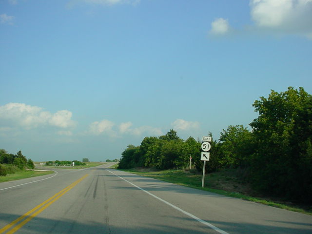
U.S. 270 East/U.S. 281 South/OK 3
East/
OK 51 East at OK 51 East. (Photo taken
5/7/04) |
 |
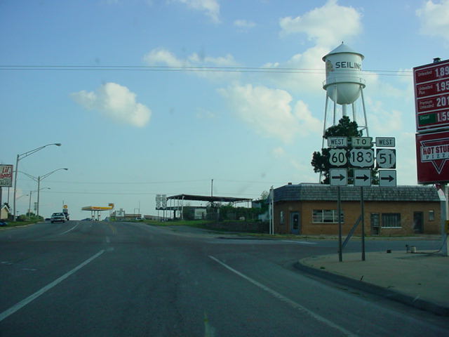
U.S. 270/OK 3 East/U.S. 60 West/U.S. 281
South at U.S. 60/OK 51 West in
Seiling.
(Photo taken 5/7/04) |
 |
U.S. 281 North at OK 14 North in
Waynoka.
OK 45 also begins here and duplexes with
U.S. 281 for 12 miles. (Photo taken 4/9/04) |
 |
U.S. 281 South/OK 45 West at OK 14
North
in Waynoka. This marks the western terminus
of OK 45. (Photo taken 4/9/04) |
 |
U.S. 64 West/U.S. 281 South at U.S.
281
South in Alva. (Photo taken 4/9/04) |
 |
U.S. 64 East/U.S. 281 North at U.S.
281
North. (Photo taken 4/9/04) |
 |
U.S. 281 North at OK 11. Kansas lies
just
seven miles ahead. This intersection marks the
western terminus of OK 11, which finds its
eastern end at Interstate 244 in Tulsa. (Photo
taken 4/9/04) |
|