|

Home
Intersecting Highways:
Interstate 35
Interstate 44
U.S. 59
U.S. 64
U.S. 69
U.S. 75
U.S. 77
U.S. 81
U.S. 169
U.S. 177
U.S. 183
U.S. 270
U.S. 281
U.S. 283
U.S. 412
OK 2 (N)
OK 3
OK 8
OK 10
OK 11
OK 18
OK 28
OK 34
OK 45
OK 46
OK 51
OK 58 (N)
OK 66
OK 74 (N)
OK 82 (N)
OK 85
OK 99
OK 123
OK 125
OK 132
OK 137
OK 156
Latest Updates
Interstate Highways
U.S. Highways
State Highway
Terminus Gallery
E-mail
OKHighways.com
(Spam filter in effect: Use @ in place of #) |
|
Highway
Review:
U.S. 60 runs from the middle of the Arizona desert off Interstate
10 east of Quartzsite to U.S. 58 in Virginia Beach, Virginia, on
the shores of the Atlantic Ocean. It travels through Arizona, New
Mexico, Texas, Oklahoma, Missouri, Kentucky, West Virginia, and
Virginia.
U.S. 60 enters the
state of Oklahoma from the northern Texas panhandle. It
immediately becomes duplexed with OK 51 upon entry into the
Sooner State, and they remain duplexed for over 60 miles. After
splitting south of Seiling, U.S. 60 then heads north and joins
U.S. 270, U.S. 281, and OK 3. In Seiling, U.S. 60 and U.S. 281
depart to the north duplexed while U.S. 281 and OK 3 continue
northwest. Four and a half miles later, U.S. 60 heads east on its
own for the first time in Oklahoma.
North of the town of Fairview, U.S.
60 becomes duplexed with U.S. 412. The two U.S. highways are joined for almost
34 miles until they split in Enid. U.S. 60 heads north with U.S. 81 in Enid,
which is the county seat of Garfield County. After heading north for 15 miles,
with U.S. 81 (and U.S. 64, which joins the two highways in North Enid), U.S. 60
and U.S. 81 head east for four more miles before U.S. 60 becomes single once
again. A short duplex near Lamont with OK 74 is all that lies between U.S. 81
and Interstate 35. At the interstate, U.S. 60 becomes a 4-lane divided highway
with a 70 mph speed limit and interchanges at major intersections for 12 miles
between Interstate 35 and Business U.S. 60 in Ponca City. U.S. 77 and U.S. 177
join U.S. 60 for 12 miles, where the combinations of U.S. 60 East/U.S. 77
North/U.S. 177 South and vice versa exist. In southeast Ponca City, U.S. 77
heads north and U.S. 177 heads south, ending the triplex of three U.S. highways.
U.S. 60 enters the
Osage Indian Reservation just after leaving Ponca City. This is
the least exciting part of U.S. 60 in the state in terms of
highway intersections and towns along the way. In a 60-mile
stretch, there are just two highway intersections: OK 11/18 near
Burbank and OK 99 in Pawhuska. OK 11 and OK 99 share time with
U.S. 60 in the reservation. After leaving the reservation,
motorists will soon enter Bartlesville, where U.S. 60 heads south
for a mile and a half with U.S. 75. The next town and highway
intersections are found in Nowata and U.S. 169, about 17 miles
east of Bartlesville.
West of Vinita, U.S.
60 becomes duplexed with U.S. 69 for the beginning of a 22-mile
stretch. U.S. 60 heads east at the interchange located within the
interchange of Interstate 44's Exit 302. U.S. 60 traffic heads
east, while U.S. 59 (which is duplexed with U.S. 60 and U.S. 69
for less than a mile at this point) and U.S. 69 North traffic
continue straight ahead. Just three intersections with Oklahoma
state highways (OK 125, OK 137, and OK 10) and a short duplex
with OK 10 later, U.S. 60 leaves Oklahoma and enters Missouri,
where it makes its way towards Springfield.
Highway
Information:
Distance: 352.8 miles
Counties traveled through: Ellis, Dewey, Major, Garfield, Grant,
Kay, Osage, Washington, Nowata, Craig, Delaware, Ottawa
Highway intersections: U.S. 283 (Mile 6.7), OK 46 (Mile 12.7),
U.S. 283 (Mile 13.7), OK 34 (Mile 39.6), OK 34 (Mile 40.5), U.S.
183 (Mile 58.8), U.S. 270/281/OK 3/51 (Mile 60.6), U.S. 270/OK 3
(Mile 61.2), U.S. 281 (Mile 65.7), OK 58 (Mile 91.9), OK 8/58
(Mile 92.9), U.S. 412 (Mile 98.8), OK 8 (Mile 101.7), OK 58 (Mile
112.6), OK 132 (Mile 124.5), OK 132 (Mile 125.5), U.S. 81/412
(Mile 132.5), U.S. 64 (Mile 136.9), OK 45 (Mile 137.9), U.S. 64
(Mile 151.9), U.S. 81 (Mile 156.0), OK 74 (Mile 169.1), OK 74
(Mile 171.0), Interstate 35 (Mile 182.5), Business U.S. 60 (Mile
184.5), U.S. 77/177 (Mile 186.1), OK 156 (Mile 194.1), Business
U.S. 60 (Mile 194.6), U.S. 77/177/Business U.S. 60 (Mile 198.1),
OK 11/18 (Mile 219.6), OK 11/99 (Mile 240.9), OK 99 (Mile 245.9),
OK 123 (Mile 264.1), U.S. 75 (Mile 267.7), U.S. 75 (Mile 269.3),
Alternate U.S. 169 (Mile 286.6), U.S. 169 (Mile 287.0), OK 28
(Mile 295.1), OK 66 (Mile 310.2), U.S. 69 (Mile 311.5), OK 2
(Mile 315.4), Interstate 44 (Mile 316.4), OK 82 (Mile 320.8), OK
85 (Mile 325.3), U.S. 59 (Mile 332.6), Interstate 44/U.S. 59/69
(Mile 333.2), OK 125 (Mile 338.3), OK 137 (Mile 344.5), OK 10
(Mile 347.3), OK 10 (Mile 347.8)
Highway duplexes: OK 51 (Miles 0.0-60.6, 60.6 miles), U.S. 283
(Miles 6.7-13.7, 7.0 miles), OK 34 (Miles 39.6-40.5, 0.9 miles),
U.S. 270/OK 3 (Miles 60.6-61.2, 0.6 miles), U.S. 281 (Miles
60.6-65.7, 5.1 miles), OK 58 (Miles 91.9-92.9, 1.0 mile), OK 8
(Miles 92.9-101.7, 8.8 miles), U.S. 412 (Miles 98.8-132.5, 33.7
miles), OK 132 (Miles 124.5-125.5, 1.0 mile), U.S. 81 (Miles
132.5-156.0, 23.5 miles), U.S. 64 (Miles 136.9-151.9, 15.0
miles), OK 74 (Miles 169.1-171.0, 1.9 miles), U.S. 77/177 (Miles
186.1-198.1, 12.0 miles), OK 11 (Miles 219.6-240.9, 21.3 miles),
OK 99 (Miles 240.9-245.9, 5.0 miles), U.S. 75 (Miles 267.7-269.3,
1.6 miles), U.S. 69 (Miles 311.5-333.2, 21.7 miles), U.S. 59
(Miles 332.6-333.2, 0.6 miles), OK 10 (Miles 347.3-347.8, 0.5
miles)
PICTURES
 |
"Welcome to Oklahoma" sign on U.S. 60 East
as the highway
enters the Sooner State. This is also the beginning of OK 51
East. (Photo taken 5/6/04) |
 |
U.S. 60/OK 51 East assurance shields
just east of the Texas
State Line. U.S. 283 is about seven miles ahead. (Photo taken
5/6/04) |
 |
U.S. 60/OK 51 East at U.S. 283
North. U.S. 283 spends seven
miles riding along with U.S. 60 and OK 51. (Photo taken 5/6/04) |
 |
U.S. 60/OK 51 West/U.S. 283 North at
U.S. 283 North. (Photo
taken 5/6/04) |
 |
U.S. 60/OK 51 West/U.S. 283 North at
OK 46 North. (Photo
taken 5/6/04) |
 |
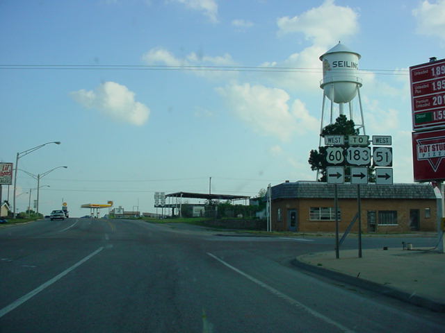
U.S. 270/OK 3 East/U.S. 60 West/U.S.
281 South at U.S. 60/
OK 51 West in Seiling. (Photo taken 5/7/04) |
 |
U.S. 60 East/OK 58 North at OK 8
South/OK 58 North in Fairview.
(Photo taken 4/9/04) |
 |
U.S. 60 East/OK 8 North at U.S. 412.
U.S. 60 is mistakenly
signed as OK 60 throughout this intersection. This marks the
western end of U.S. 60's 34-mile duplex with U.S. 412. (Photo
taken 4/9/04) |
 |
OK
(U.S.) 60/U.S. 412 East/OK 8 North
assurance shields just
east of
the intersection above. OK 8 will depart from this multiplex
in
three miles. (Photo taken 4/9/04) |
 |
U.S. 60/U.S. 412 East/OK 8 North at
OK 8 North. (Photo
taken 4/9/04) |
 |
U.S. 60/U.S. 412
West/OK
132 South at OK 132 South.
OK 132
runs along the highways for a mile. (Photo taken
7/18/03) |
 |
U.S. 60/U.S. 412
West at OK 132 North. (Photo taken 7/18/03) |
 |
U.S. 60 West/U.S.
81 South at U.S. 412 in Enid. After being
duplexed with U.S. 81 for the last 23.5 miles, U.S. 60
now gets to
be duplexed with U.S. 412 for the next 34 miles. (Photo
taken
7/18/03) |
 |
U.S. 60 West/U.S.
64 East/U.S. 81 South at U.S. 64 East in
North Enid. (Photo taken 7/18/03) |
 |
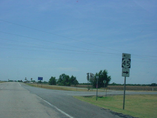
U.S. 60 West/U.S.
64 East/U.S. 81 South at OK 45 West.
(Photo taken 7/18/03) |
 |
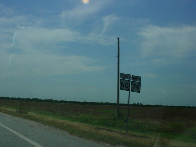
U.S. 60 East/OK 74 North assurance shields east of OK 74
South. The duplex lasts two miles as the highways travel
through the town of Lamont. (Photo taken 7/18/03) |
 |
U.S. 60 East/OK 74
North at OK 74 North, east of Lamont. U.S.
60 will intersect Interstate 35 in 12 miles. (Photo
taken 7/18/03) |
 |
U.S. 60 East
assurance shield just east of Interstate 35. The
highway is a 4-lane divided highway between the
interstate and
Ponca City with interchanges at U.S. 77, U.S. 177, OK
156, and
Business U.S. 60. (Photo taken 2/14/03) |
 |
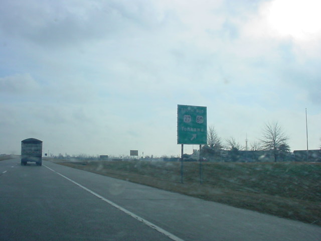
U.S. 60 East at
Business U.S. 60/U.S. 77 South exit north of
Tonkawa. U.S. 77 joins U.S. 60 here for about 12 miles. (Photo
taken 2/14/03) |
 |
U.S. 60 East/U.S.
77 North/U.S. 177 South at the OK 156 South -
Marland exit. OK 156 runs along the former routing of
U.S. 77
before it was moved to the west. (Photo taken
2/14/03) |
 |
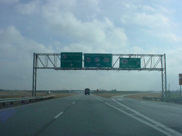
U.S. 60 East/U.S.
77 North/U.S. 177 South at Business U.S. 60 in
Ponca City. The business route runs along U.S. 60's
former route
into Ponca City, which has a population of 25,919. (Photo
taken
1/7/03) |
 |
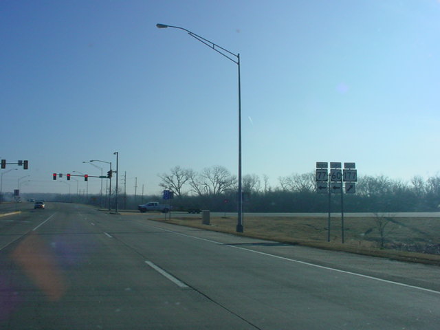
U.S. 60 East/U.S.
77 North/U.S. 177 South at U.S. 77 North/U.S.
177 South in Ponca City. U.S. 60 will enter the Osage
Indian
Reservation just after this stoplight. (Photo taken
1/7/03) |
 |
U.S. 60 East at OK
11 West/OK 18. OK 11 joins U.S. 60 here and
they remain duplexed for 21 miles until OK 11 heads south
at OK
99, then U.S. 60 gets duplexed with OK 99. (Photo
taken 1/7/03) |
 |
Another view of
U.S. 60 East at OK 11 West/OK 18, taken a
month later. (Photo taken 2/14/03) |
 |
U.S. 60/OK 11
East
at OK 99 just east of Pawhuska. OK 11
heads right here and duplexes with OK 99 South, while
U.S. 60
East heads to the left and duplexes with OK 99 North. (Photo
taken 2/14/03) |
 |
U.S. 60 East/OK 99
North assurance shields just north of the
U.S. 60/OK 11/99 intersection pictured above. U.S. 60
will split
from OK 99 in five miles. (Photo taken 2/14/03) |
 |
U.S. 60 East/OK 99
North at U.S. 60 East. OK 99 will see one
more highway, OK 10, before entering the state of Kansas,
and
becoming its state highway 99. U.S. 60, meanwhile,
continues on
towards Bartlesville. (Photo taken 2/14/03) |
 |
U.S. 60 West at OK 66 West near White Oak. OK 66 runs along
former U.S. 66 between El Reno and this intersection. (Photo
taken 4/25/03) |
 |
U.S. 60 East at
U.S. 69 west of Vinita. U.S. 69 joins U.S. 60 for
the next 21 miles. (Photo taken 4/25/03) |
 |
U.S. 60 East/U.S.
69 North at OK 2 North in Vinita. OK 66, still
signed here, actually ends five miles to the west of
here. (Photo
taken 4/25/03) |
 |
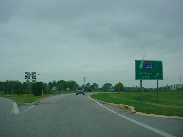
U.S. 60 West/U.S.
69 South at Interstate 44 in Vinita. (Photo
taken 4/25/03) |
 |
U.S. 60 West/OK 125
South at OK 125 South in Fairland. The
two highways share a short duplex. (Photo taken
4/25/03) |
 |
U.S. 60 West/OK 125
South approaching OK 125 South. Due
to bridge construction in the area, OK 125 was being used
as
a detour. Notice the California-style U.S. 69 shield. It
probably
was once used as an Alternate U.S. 69 shield before that
highway became OK 69A in late 2002. (Photo taken
4/25/03) |
 |
U.S. 60 West at OK
125 North in Fairland. (Photo taken 4/25/03) |
 |
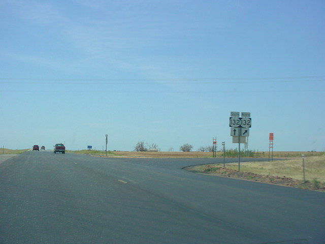
U.S. 60 West at OK
137 North. At least, that's what the signs
seem to indicate. OK 137 is actually about 1/2 mile
ahead. U.S.
60 still has to cross the Spring River. (Photo taken
4/25/03) |
 |
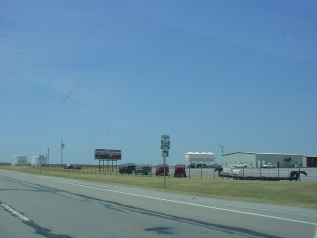
U.S. 60 West at OK
137 North in Twin Bridges State Park. The
Neosho and Spring rivers flow into Grand Lake just south
of
this intersection. OK 137 is just five miles long and
connects
U.S. 60 to OK
10. (Photo taken
4/25/03) |
 |
U.S. 60 West/OK 10
North at OK 10 North. (Photo taken
4/25/03) |
 |
U.S. 60 West at OK
10 South. (Photo taken 4/25/03) |
 |
U.S. 60 West at
Business U.S. 60. The business route connects
to Seneca, Missouri, which is just a mile to the
northeast. (Photo
taken 4/25/03) |
 |
"Oklahoma"
sign as U.S. 60 West enters the Sooner State.
(Photo taken 4/25/03) |
|