|

Home
Roadklahoma Links:
Home
Terminus Page
OK 11 Page
Intersecting Highways:
Interstate 35
Interstate 244
U.S. 60
U.S. 64
U.S. 75
U.S. 77
U.S. 81
U.S. 177
U.S. 281
U.S. 412
OK 8
OK 11A
OK 18
OK 20
OK 38
OK 58 (N)
OK 74 (N)
OK 99
OK 123
OK 132
Latest Updates
Interstate
Highways
U.S. Highways
State Highway
Terminus Gallery
E-mail OKHighways.com
(Spam filter in effect: Use @ in place of #) |
|
OKHighways.com
Terminus Gallery |
| |
|
 |
Highway History:
OK 11 once duplexed with U.S. 60 from U.S. 77 in Ponca City to OK 99
in Pawhuska. At that time, current OK 11 between U.S. 77 and OK 18 in Shidler was
OK 119. OK 119 was then decommissioned, and OK 11 was signed along the highway's
entire length. U.S. 60 and OK 11 still have a duplex, but it now begins at OK 18
in the Osage Indian Reservation.
Highway Review:
At a distance of 206 miles, OK 11 is Oklahoma's 8th longest state
highway. It starts at U.S. 281 north of Alva and ends at
Interstate 244 in Tulsa. The highway runs north-south for much of
its final 75 miles. OK 11 also shares long duplexes with U.S. 60
and OK 18 in the Osage Indian Reservation. OK 11 is the farthest
north east-west state highway in north-central Oklahoma.
Highway Information:
Distance: 206.0 miles
Counties traveled through: Woods, Alfalfa, Grant, Kay, Osage,
Washington, Tulsa
Highway intersections: U.S. 281 (Mile 0.0), OK 8 (Mile 8.9), OK
58 (Mile 15.9), U.S. 64/OK 8/58 (Mile 23.0), OK 38 (Mile 33.9),
OK 132 (Mile 40.9), OK 11A (Mile 46.9), U.S. 81 (Mile 57.8), OK
74 (Mile 67.8), Interstate 35 (Mile 79.3), U.S. 177 (Mile 82.7),
U.S. 77 (Mile 94.7), U.S. 77 (Mile 97.7), OK 18 (Mile 120.6),
U.S. 60/OK 18 (Mile 129.3), U.S. 60/OK 99 (Mile 150.7), OK 99
(Mile 155.0), OK 123 (Mile 166.7), OK 20 (Mile 186.5), U.S. 75
(Mile 200.1), U.S. 75 (Mile 200.8), Interstate 244/U.S. 412 (Mile
206.0)
Highway duplexes: OK 8 (Miles 8.9-23.0, 14.1 miles), OK 58 (Miles
15.9-23.0, 7.1 miles), U.S. 77 (Miles 94.7-97.7, 3.0 miles), OK
18 (Miles 120.6-129.3, 8.7 miles), U.S. 60 (Miles 129.3-150.7,
21.4 miles), OK 99 (Miles 150.7-155.0, 4.3 miles), U.S. 75 (Miles
200.1-200.8, 0.7 mile)
WESTERN
TERMINUS
U.S. 281, north
of Alva
 |
"END OK 11" sign on
OK 11 West at U.S. 281.
(Photo
taken 4/9/04) |
 |
OK 11
East assurance shield just east of U.S. 281. OK 8 is
nine miles ahead. (Photo taken 4/9/04) |
 |
U.S.
281 North at OK 11 East. Pardon the windshield
wiper; at least the rain had settled down quite a bit from
just a minute before this picture! (Photo taken 4/9/04) |
OTHER
HIGHWAY PICTURES
 |
OK
11 East at OK 8 North.
(Photo taken 4/9/04) |
 |
OK
8 South/OK 11 East at OK 8 South/OK
11 East/OK 58.
OK 58 North takes over this road, while OK 11 East and OK
8 South both turn right. (Photo taken 4/9/04) |
 |
OK
8 South/OK 11 East/OK 58 South
assurance shields
just south of the northern end of their multiplex. (Photo
taken 4/9/04) |
 |
OK
8/OK 58 South/OK 11 East at U.S. 64
West/OK 11
East. The direct connectors from south to west, east to
south, north to east, and from west to north, were all closed
for reconstruction. (Photo taken 4/9/04) |
 |
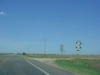
OK 11 West at OK 38 South. OK 38 connects to the Great
Salt Plains State Park and U.S. 64. (Photo taken
7/18/03) |
 |
OK 11 West at OK 132. (Photo taken 7/18/03) |
 |
OK 11 West at OK 11A North. OK 11A is the only lettered
spur of OK 11, and it connects to the town of Wakita,
five
miles to the north. Notice the right turn arrow sign is
missing
from the sign assembly. (Photo taken 7/18/03) |
 |
OK 11 West at U.S. 81 in Medford. Medford, the county
seat of Grant County, is home to 1,172 residents. (Photo
taken 7/18/03) |
 |
OK 11 West at OK 74 South. OK 74 connects to Interstate 44
and OK 66 in Oklahoma City at its other end. In between,
the
highway spurs off four lettered routes. (The southern OK
74
has two, for a total of six lettered spurs of OK 74!) (Photo
taken 7/18/03) |
 |
OK 11 West at
Interstate 35 North. This interchange provides
the final fast food joints and chain hotels in Oklahoma
for those
heading towards Kansas. (Photo taken 9/28/02) |
 |
OK 11 West/OK 18 North at OK 11 West in Shidler. The two
highways share nine miles of pavement. (Photo taken
1/7/03) |
 |
OK 11 East/OK 18
South at U.S.
60. OK 11 heads off to the
left (east) and duplexes with U.S. 60 for the next 21
miles.
(Photo taken 1/7/03) |
 |
OK 18 North/OK 11
West assurance shields just north of U.S.
60. The town of Shidler and the northern end of this
duplex
are nine miles ahead. (Photo taken 1/7/03) |
 |
OK 11 East
assurance shield just east of OK 123. The
next
highway intersection is OK 20 in 20 miles. (Photo
taken
2/14/03) |
 |
OK 11 East at OK 20 in Skiatook. OK 20 spans 143 miles
from OK 18 near Ralston to the Missouri State Line. OK 20
travels through the towns of Hominy, Claremore, Pryor,
and
Jay along its route. (Photo taken 2/14/03) |
 |
OK 11 West at U.S.
75 North/OK 11 West - Bartlesville
exit in Tulsa. This was the western end of the Gilcrease
Expressway at the time of this photo. Since that time,
the
highway has been extended west 1/2 mile to Lewis Ave.,
and
long-term plans call for it to extend to the stub
northern end of
the L.L. Tisdale Parkway. OK 11 will then be rerouted
along
the new alignment to Peoria Ave., where the highway will
head to the north. (Photo taken 4/25/03) |
 |
OK 11 East at
Harvard Ave. (Photo taken 4/25/03) |
 |
OK 11 West at
Harvard Ave. U.S. 75 is 3/4 mile ahead.
(Photo taken 4/25/03) |
 |
OK 11 East at Yale
Ave. (Photo taken 4/25/03) |
 |
OK 11 West at Yale
Ave. (Photo taken 4/25/03) |
 |
OK 11 East at
Apache St./Sheridan Rd. (Photo taken
4/25/03) |
 |
OK 11 West at
Sheridan Rd. exit. (Photo taken 4/25/03) |
 |
OK 11 East at
Airport Terminal exit. The eastern terminus of
OK 11 is 1 1/2 miles ahead at Interstate 244/U.S. 412.
(Photo taken 4/25/03) |
 |
OK 11 West at
Virgin St./Airport Terminal exit. (Photo taken
4/25/03) |
 |
OK 11 East at
Memorial Dr. exit. (Photo taken 4/25/03) |
 |
OK 11 West at Pine
St. exit. (Photo taken 4/25/03) |
 |
It's coming right
for us! An airplane prepares to land at
Tulsa International Airport, which is just a mile to the
north.
The left edge of the sign gantry for OK 11 West at Pine
St. is
visible to the left. (Photo taken 4/25/03) |
EASTERN
TERMINUS
Interstate
244/U.S. 412, Tulsa
 |
"END OK
11" sign as the highway nears its end at Interstate
244/U.S. 412. The federal highways are about 1/2 mile
ahead. (Photo taken 4/25/03) |
 |
OK 11 East at
Interstate 244/U.S. 412 West - Downtown
exit. The left lane defaults onto Interstate 244/U.S. 412
East. U.S.
169 is a mile east of this
interchange. (Photo
taken 4/25/03) |
 |
Interstate 244/U.S.
412 West at Exit 12B - OK 11 West -
Tulsa Int'l Airport. The airport is just a couple miles
to the
north. (Photo taken 4/25/03) |
|


