|

Home
Roadklahoma Links:
Home
Terminus Page
OK 4 (W) Page
Intersecting Highways:
Interstate 40
Interstate 44
OK 3
OK 37
OK 66
OK 152
Latest Updates
Interstate Highways
U.S. Highways
State Highway
Terminus Gallery
E-mail
OKHighways.com
(Spam filter in effect: Use @ in place of #) |
|
OKHighways.com
Terminus Gallery |
| |
|

(WEST) |
Highway History:
In 1953, there was only one OK 4, and it only went as far south as U.S. 66
in Yukon. Besides that, the highway ran along the same route as it does today
from U.S. 66 to Piedmont.
Highway Review:
OK 4 is a mostly 4-lane highway connecting the west
Oklahoma City suburbs of Piedmont, Yukon, Mustang, and Tuttle.
Until the completion of the South Canadian River bridge in late
2001, OK 4 had its southern terminus at its intersection with OK
152 in Mustang. Now the highway is co-signed with OK 152 for a
mile and then OK 4 breaks off again and continues heading south
to the Tuttle area. OK 4 is also co-signed with OK 66 for about
1/4 mile in Yukon. Construction on OK 4 between Interstate 44 and
OK 37 was completed in October 2002, but the highway wasn't
signed on that section until March 2003.
Highway Information:
Distance: 29.5 miles
Counties traveled through: Grady, Canadian
Highway intersections: Interstate 44/H.E. Bailey Turnpike Spur
(Mile 0.0), OK 37 (Mile 4.0), OK 152 (Mile 9.6), OK 152 (Mile
10.6), Interstate 40 (Mile 16.1), OK 66 (Mile 19.2), OK 66 (Mile
19.5), OK 3 (Mile 26.2)
Highway duplexes: OK 152 (Miles 9.6-10.6, 1.0 mile), OK 66 (Miles
19.2-19.5, 0.3 miles)
SOUTHERN
TERMINUS
Interstate 44,
Newcastle
Perspective from OK
4 South:
 |
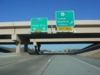
OK 4 South
approaching Interstate 44-2 miles. The last chance to
turn off
the highway before tolls is in 1/2 mile. (Photo taken
4/11/03) |
 |
OK 4 South
at Interstate 44 West. The toll plaza for Interstate 44
is just a
couple miles south of this interchange. (Photo taken
4/11/03) |
 |
OK 4 South
at Interstate 44 East. I have no idea what the green out
and
extra space is for. Maybe an "END OK 4" sign?
At the time of this
photograph, there was no end sign at this terminus. (Photo
taken 4/11/03) |
Perspective from
H.E. Bailey Turnpike Spur West:
 |
H.E.
Bailey Turnpike Spur West at Interstate 44 East - Oklahoma
City
exit. Even though OK 4 is signed here, it wasn't actually signed between
here and OK 37 until two months after this picture was taken. (Photo
taken 1/31/03) |
 |
The H.E. Bailey Turnpike Spur
(also known as the Norman Spur) ends
with the exit for Interstate 44 West. The road continues as a 4-lane
divided highway for another 1/2 mile before narrowing to two lanes.
(Photo taken 1/31/03) |
Perspective from
Interstate 44 East:
 |
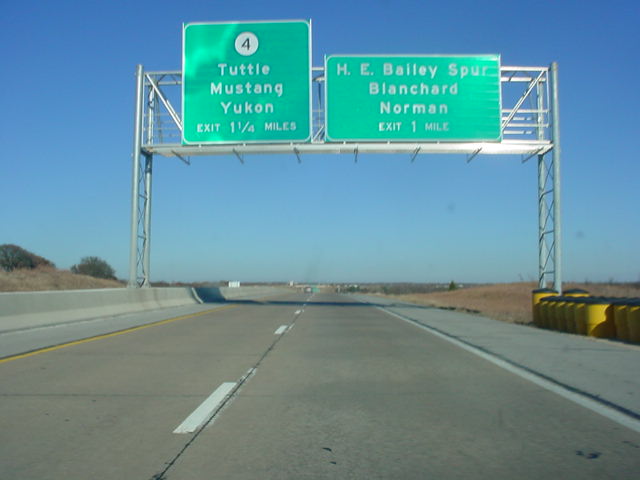
Interstate
44 East approaching the H.E. Bailey Spur - 1 mile,
and OK
4 - 1 1/4
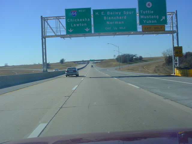
miles. (Photo taken 11/22/02) |
 |
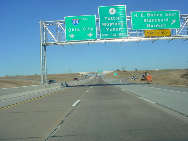
Interstate
44 East at the H.E. Bailey Spur exit. This exit is a standard
cloverleaf
built in 2001 for the new turnpike spur which connects
Interstate 44 to OK 9 north
of Blanchard, providing access to Norman
and points
beyond. (Photo taken
11/22/02) |
 |
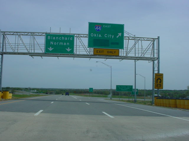
And
finally, Interstate 44 East at OK 4 North exit. (Photo
taken 11/22/02) |
Perspective from
Interstate 44 West:
 |
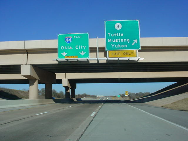
Interstate
44 West approaching OK 4 - 1 mile. At the time this photo
was
taken,
construction was still underway on OK 4. (Photo taken
10/11/02) |
 |
View of
the same gantry over a month later. (Photo taken
11/22/02) |
 |
Interstate
44 West at OK 4 exit (unmarked Exit 99). (Photo taken
10/11/02) |
 |
View of
the same gantry a month later without the cities covered
up. It
also
appears that the sign has been replaced with one for
three control
cities; the one
above looks like it has room for only two. (Photo
taken
11/22/02) |
FORMER
SOUTHERN TERMINUS
OK 37, Tuttle
Perspective from OK
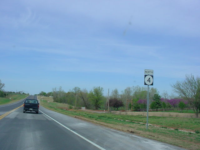
4 North:
 |
View of
the widening from then-future OK 4 North. OK 37 is
approaching in
about 1/2 mile. The highway from here southward to
1/2 mile north of Interstate 44 is
2-laned. (Photo taken 11/22/02) |
 |
About five months
later, the first northbound assurance shield is located
at
about the same spot where OK 4 widens to four lanes (plus
a middle
turn lane).
(Photo taken 4/11/03) |
 |
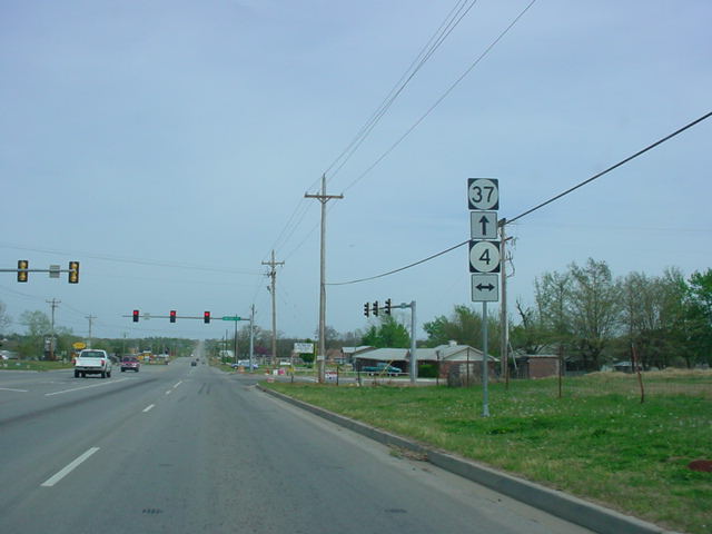
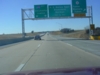
OK 4 North at OK
37. (Photo taken 4/11/03) |
 |
OK 4 North
assurance shield just north of OK 37. The highway will
enter
Mustang
and join OK 152 in less than six miles. (Photo taken
1/31/03) |
Perspective from OK
4 South:
 |
"END OK 4" sign as
OK 4 South came to an end. For about 1
1/2 years,
OK 4 ended at this intersection. (Photo
taken 8/24/02) |
 |
The
construction of the southward extension of OK 4 can be
seen in
this picture
as taken from its then-southern terminus at OK 37. The
highway now ends at
Interstate 44. (Photo taken 8/24/02) |
 |
A view of
the construction from OK 4 South three months later. The
road
itself is
now complete to Interstate 44. (Photo taken 11/22/02) |
 |
Same "END OK
4" sign as above, seen five months later.
Construction
was still
going on, but the road was almost complete. OK 4 would
finally
be signed between
here and Interstate 44 in March 2003. (Photo taken
1/31/03) |
 |
Same spot as
before, but now OK 4 continues straight ahead instead of
ending
here. It now continues for four more miles to Interstate
44. But the
new southern
terminus does not have an "END OK 4" sign! (Photo
taken
4/11/03) |
 |
OK 4 South
assurance shield just south of OK 37. (Photo taken
4/11/03) |
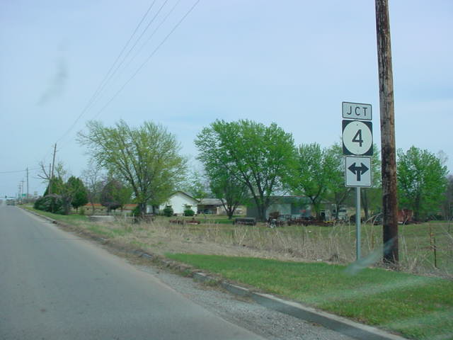
Perspective from OK
37 West:
 |
OK 37 West at OK 4. (Photo
taken 10/4/02) |
 |
Several months
later, OK 4 had
been
extended down to Interstate 44, so
now the directional
signage indicates that
both directions are OK 4. (Photo
taken 4/11/03) |
Perspective from OK
37 East:
 |
OK 37 East
approaching OK 4. For some reason, both directions of OK
37
have this unusual T directional sign below the "JCT
OK 4" signage. (Photo
taken 4/11/03) |
 |
OK 37 East at OK 4.
OK 37 will intersect OK 76 at that highway's northern
terminus in four miles. (Photo taken 4/11/03) |
OTHER
HIGHWAY PICTURES
 |
OK 4 South on the
South Canadian River bridge. The bridge was completed
in
late 2001
and provides a connection between Mustang to the north
and
Tuttle to the south. Before
the bridge was completed, one would have to cross
the
river on U.S. 81 or Interstate 44,
both about 10 miles out of the way. (Photo
taken
8/24/02) |
 |
OK 4
North at OK 152 in Mustang. (Photo
taken 1/31/03) |
 |
OK 4 South/OK 152
East at the OK 4 split in Mustang. Traffic on OK 152
used
to be
able to go through this intersection without stopping for
a light, but with the
extension of
OK 4, there is now a stoplight present here. (Photo
taken 8/24/02) |
 |
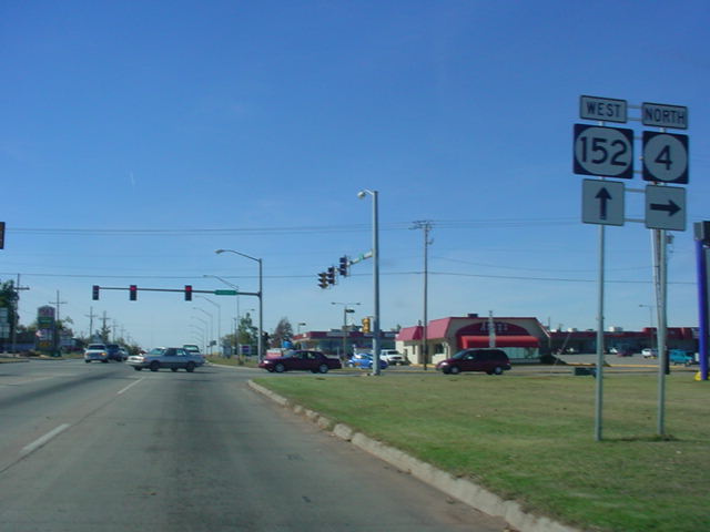
OK 152 East/OK 4
North shields just west of OK 4 in Mustang. The two
highways
now
have one mile of road together in the fast-growing
Oklahoma City suburb.
(Photo taken
1/31/03) |
 |
OK 4 North/OK 152
West at OK 4 in Mustang. The "JCT OK 4" sign
approaching this
intersection is still there, even though it is no longer
necessary
with the extension of OK
4 southward to OK 37 and Interstate 44. (Photo taken
11/13/02) |
 |
Another view of OK
4 North/OK 152 West at OK 4 North in Mustang. The
aforementioned
"JCT OK 4" sign that is no longer needed was
still there when I
was in the area. (Photo
taken 1/31/03) |
 |
OK 4 South at OK
152 in Mustang. This is the former southern terminus of
OK 4.
Now, traffic for OK 4 turns left here and joins OK 152 for a mile before
splitting
at the
intersection pictured above this one. (Photo taken
8/24/02) |
 |
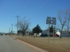
OK 4 North at S.W.
15th St. between Mustang and Yukon. The Kilpatrick
Turnpike
begins
about 2/3 mile east of this intersection, thus the
mention of the turnpike is
made. (Photo
taken 11/13/02) |
 |
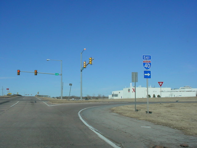
OK 4 North at
Interstate 40 East in Yukon. The area south of the
interstate has
been the
site of much development in recent years, with several
strip malls and
other businesses
being built. (Photo taken 1/31/03) |
 |
OK 4 North at
Interstate 40 West in Yukon. This interchange is located
1/2 mile
to the west
of the Kilpatrick Turnpike. The two exits share some
ramps off the
interstate. (Photo taken
1/31/03) |
 |
OK 4 North at OK 66
East in Yukon. (Photo taken 1/31/03) |
 |
OK 4 North at OK 66
West in Yukon. OK 4 heads to the west here for about
1/4
mile
before splitting from OK 66. (Photo taken 1/31/03) |
 |
OK 4 South/OK 66
East at the OK 4 South splitoff in Yukon. (Photo
taken
11/26/02) |
 |
OK 4 North/OK 66
West at OK 4 North in Yukon. OK 4 between here and OK 3
is 2-laned
with a 45 mph speed limit. The next highway junction is
OK 3, seven
miles to the north.
(Photo taken 1/31/03) |
 |
OK 4 South at its
intersection with OK 66 in Yukon. OK 4 is multiplexed
with OK
66 for only
about 1/4 mile, then OK 4 splits off again heading
towards the
southeast. (Photo taken
8/24/02) |
 |
OK 4 North at OK 3.
OK 3 is Oklahoma's longest state highway at over 600
miles.
It starts
at the Colorado State Line in the panhandle and goes all
the way to the
far southeast
corner of Oklahoma. (Photo taken 1/31/03) |
 |
OK 4 South at OK 3
south of Piedmont. This is the first (or final, depending
on
direction of
travel) highway intersection on OK 4. There is a 4-way
stop present
at this intersection.
(Photo taken 8/24/02) |
NORTHERN
TERMINUS
Edmond Rd.,
Piedmont
 |
"END" sign on
OK 4 North at Edmond Rd. in Piedmont. (Photo taken
8/24/02) |
|